Geospatial Toolkit 2.0

Free Geospatial Toolkit is an NREL-developed map-based application
Rating
Your vote:
Latest version:
2.0.1 See all
Developer:
National Renewable Energy Laboratory
Screenshots
1 / 4
Awards (1)
Show all awards
Software Informer Virus Free award
Trusted Download
Free   129 MB

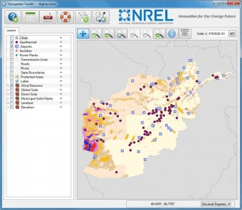
Geospatial Toolkit is an NREL-developed map-based application that integrates resource data and other geographic information systems (GIS) data for integrated resource assessment. The Geospatial Toolkit also integrates HOMER for all countries, an optimization model for distributed power.

Comments

User

Your vote:

Related software

GRASS GIS
GRASS GIS
Free
rating

Contains over 350 modules to render maps and images on monitor and paper.

Azimuth Map
Azimuth Map
Free
rating

It plots a world map in either azimuth (beam heading) or Mercator projections.

T24 Toolkit
T24 Toolkit
Free
rating

Allows configuration of the T24 range of 2.4GHz telemetry products.

TOOLKIT FOR ASTROMETRY
Free
rating

It is designed for planning observations, measuring positions from CCD frames.

Christine-GIS
Christine-GIS
Free
rating

Combines visual geographic information with sophisticated computer applications.

Related suggestions